Our Tasmania Trip...Spring 2023
The Third Part - From Tassie to Home.
Click on the location names below to see where we stayed along this part of the trip
The Third Part - From Tassie to Home.
Click on the location names below to see where we stayed along this part of the trip
Finally after three weeks and a little over 2000 km driving (2045 to be exact) in Tasmania it is time to head home. Our plan is to drive a pretty direct route, we have around 2 and a half weeks to get home so there will be no rush...as usual we dont plan ahead, at the moment there are no school holidays and we dont think there is a need to book...time will tell on that. We intend to avoid caravan parks as much as we can along the way but that is not always easy...for example our first night was to be Benalla Showgrounds but I missed the fact that power and water is not available there, quite unusual for a showground and we wanted to do some clothes washing. Instead we travelled on a bit further and stayed in Wangaratta, Victoria.
This first couple of nights in Painters Island Caravan Park. But first, our final stay in Geelong is below
This first couple of nights in Painters Island Caravan Park. But first, our final stay in Geelong is below
Geelong - Eldorado Van Pk 2.0


Wangaratta
Click here to see our trip home photos
Return to page top?..click here
Wangaratta is a city in the northeast of Victoria, 236 km from Melbourne along the Hume Highway. The city had a population of 29,808 per the 2021 Australian Census. The city is located at the junction of the Ovens and King rivers, which drain the northwestern slopes of the Victorian Alps.
We chose to stop here for a couple of nights...we needed to do some washing...it is an impressive city and we enjoyed our stay.
We chose to stop here for a couple of nights...we needed to do some washing...it is an impressive city and we enjoyed our stay.


Return to page top?..click here
Henty Showgrounds (Revisited)
Henty showgrounds were revisited, we had stayed here on the way south, it sits on the Olympic Highway some 140 km from Wangaratta. What was becoming increasingly obvious to us as we travelled north was the dryness of the country, gone were the picturesque rolling green hills that we had become used to...now the fields were brown...still quite attractive but now brown.
We found little had changed since our last visit about 5 weeks prior...hence just the one photo here. One minor confession, someone who should remain nameless, forgot to take a photo, the photo below is the same one published during our first visit....at that time we were on site 5, this time on 6..![]()
Return to page top?..click here

Forbes
Return to page top?..click here
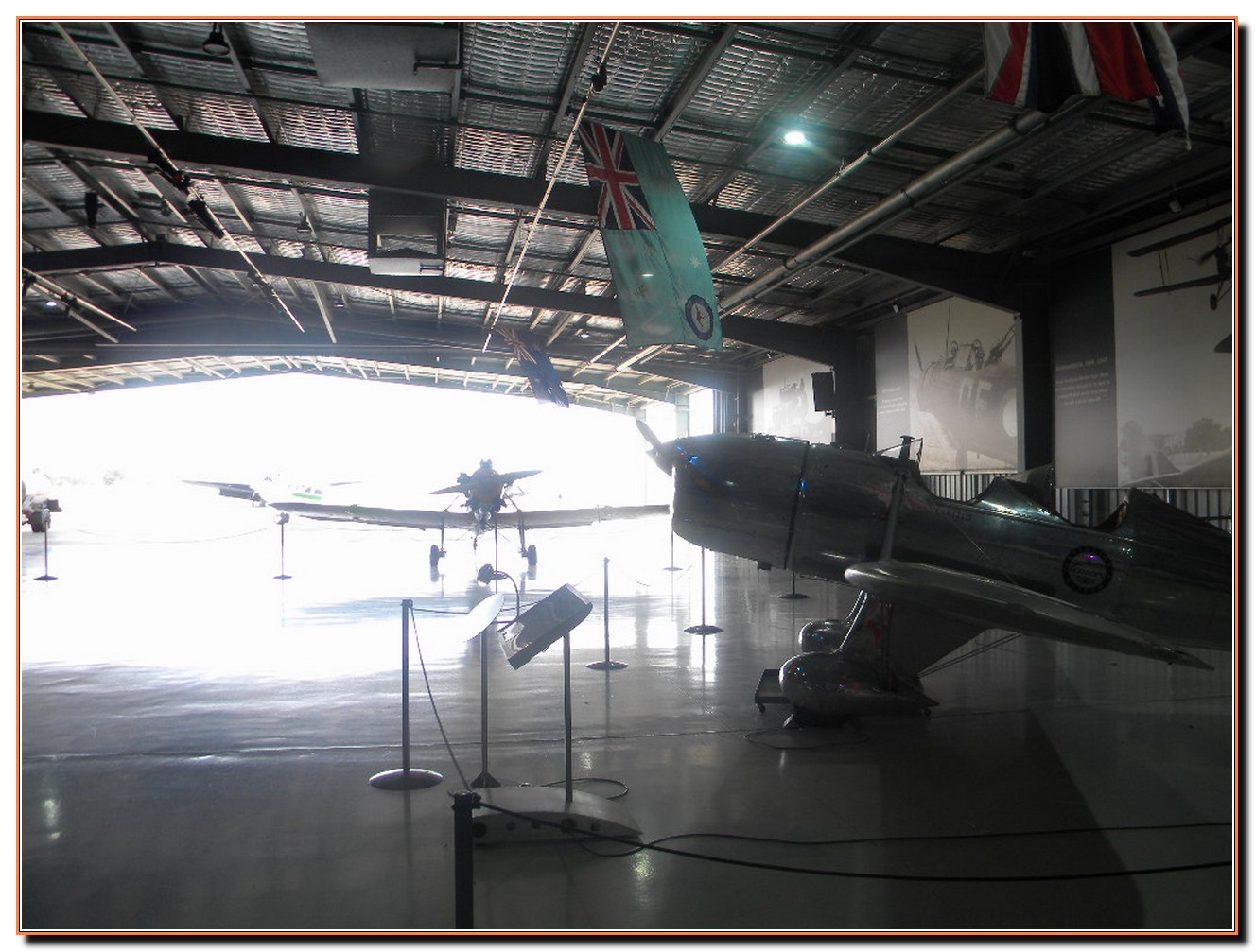
Temora is a town in the north-east of the Riverina area of New South Wales. At the 2021 census the population of Temora was 4,016 Nestled deep in Wiradjuri Country, Temora is renowned for being home to the nationally significant Temora Aviation Museum and this is one reason for our visit.
We start with some shots taken on our trip along the Olympic Highway....through the Riverina. And then Temora. Click the photo below for a slide show
We start with some shots taken on our trip along the Olympic Highway....through the Riverina. And then Temora. Click the photo below for a slide show
Return to page top?..click here
Return to page top?..click here


Temora
Well, we are here in Forbes Showground, getting here no easy matter....we pulled into West Wyalong around 11am
After leaving Temora...to get to Forbes we thought we might, yet again take the road less traveled and go via Grenfell, rather than up the Newell, we were unsure if we have even been that way before...however, at the last moment we changed our minds and ordered Sarah (the GPS lady) to take us on the most direct route via West Wyalong, our main reason for the change being the news that instability at our vessel container ports has seen a massive drop in heavy traffic on the Newell.
We had a reasonably good run to West Wyalong, albeit the roads, recently flood covered, are pothole ridden.
Arrived at WW and straight into the truck stop...we had had nothing to eat! I munched into my Truckers Burger, with relish, and BBQ sauce. Sadly cappuccino's were not partaken, all they had was one of those 'diy' things, bottled Iced Coffee sufficed.
WE left WW and 200 meters later came to a stop...'Road Accident Ahead' the sign said, followed quickly by another sign..'Road Closed', all this on one of the countries busiest routes...we were told that a fatality had occurred and the road could be closed for hours...we could either wait, along with dozens of others, for the road to reopen or we could back-track to that 'road less traveled' mentioned above...we decided to do that...by the time we made it to Forbes we had detoured 108.4km!.
Later we heard via the ABC that a utility and a semi had collided and the ute driver had died..we also heard that accident had happened at 11;45 the night before and the Newell was not reopened for 12 hours...or about the same time we were being told to detour!
Click the photo below for a slide show.
Return to page top?..click here


Return to page top?..click here
Dubbo
Leaving Forbes we continued north on the Newell Highway. The Newell is the major route for heavy vehicles traveling from Melbourne to points north...because of the number of trucks on this road we would normally avoid it and use an alternative, however, at this time..Nov 2923 a major Cyber attack has caused havoc and many containers have been locked up...hence the usual amount of trucks has been dramatically reduced. In addition, the Newell is not a bad road at all, I would suppose the importance of this road would ensure it is pretty' well maintained. There are many overtaking lanes available and there are lots of rest areas.
Dubbo is the largest population centre in the Orana region, with a population of 43,516 at June 2021. The city is located at the intersection of the Newell, Mitchell, and Golden highways.
One thing Dubbo is well known for is the Taronga Western Plains Zoo and this was our prime reason for stopping here.
Narrabri is a locality and seat of Narrabri Shire local government area in the North West Slopes, New South Wales, Australia on the Namoi River, 521 kilometres northwest of Sydney. It sits on the junction of the Kamilaroi Highway and the Newell Highway.
The Newell Highway is located entirely west of the Great Dividing Range, running largely along the foot of the western slopes of the range, and as such crosses nine major rivers, all west-flowing from the Great Dividing Range. From north to south these rivers are the Macintyre (at Goondiwindi), the Gwydir (10 km north of Moree), the Mehi (at Moree), the Namoi (near Narrabri), the Castlereagh (at Coonabarabran and again at Gilgandra), the Macquarie (at Dubbo), the Lachlan (at Forbes), the Murrumbidgee (at Narrandera), and the Murray (at Tocumwal). Some sections of the Newell Highway are subject to periodic flooding from these rivers, particularly north.
According to the 2016 census of Population, there were 13,084 people in Narrabri.
Before the arrival of the Europeans in the early 19th century, Narrabri was the home of the Gamilaroi people, who still constitute a significant part of the local population. Narrabri derives its name from an early property in the district called the Narrabry Run. The name Narrabri is aboriginal in origin and has several possible meanings which include 'snake place', 'big creek' or 'Forked Sticks'.
We had intended to visit the nearby Kaputar National Park and the Sawn Rocks,
Sadly Mother Nature appears to have other ideas!
Narrabri


Return to page top?..click here


Goondiwindi
Return to page top?..click here


This is it, our final stop...on this trip we have stopped at 31 places!...we thought there would be about four more days but the weather was not our friend.
Gundy Showgrounds were visited twice on this trip and this time just got over it all....we didnt look at any tourist things....we did do that on our first visit and if you wish to see that click here
Gundy Showgrounds were visited twice on this trip and this time just got over it all....we didnt look at any tourist things....we did do that on our first visit and if you wish to see that click here